CEDERBERG, SOUTH AFRICA
Justin Hawthorne

Photo by Kirsty Hawthorne
After a ritualistic mountain breakfast of modernised moerkoffie & buttermilk rusks, we left the comfy confines of Klipspringer Cottage at the Algeria campsite and drove up Uitkyk Pass at dawn. It was a gorgeous winter morning, abnormally warm due to the current weather patterns affecting the Western Cape, the small number of wispy clouds lit up shades of pink and purple ever so briefly.

Photo by Kirsty Hawthorne

Photo by Justin Hawthorne
Getting there
Permits acquired (free to Wild Card holders – we are!), we took the mountain jeep track that leads from Dwarsrivier Farm past the Observatory and onto the start point for the hike. The rough track is around 6km long, gaining 160m in elevation and I can’t see how it would be drivable without a high clearance vehicle.
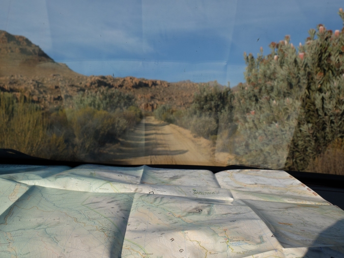
Photo by Kirsty Hawthorne
We had a Hyundai ix35 for the weekend courtesy of MLT Vehicle Hire, and the 2×4 SUV handled this stretch of road well. The drive in takes about 20min from the farm gate (combination lock – code given with permit), and you’ll reach a dead-end parking area which is the trailhead.

Photo by Justin Hawthorne
The hike
Setting off past a number of tall proteas, you’ll descend along a wide track and reach a stream, the Dwarsrivier. There’s a smart little pole footbridge over the stream, and if your balancing skills are not up to scratch you could use a few stepping stones to cross the narrow waterway – provided the water level of this little stream is low enough of course.

Photo by Justin Hawthorne
We noticed Cape clawless otter scat near the water, just off the footpath and not too far away a fresh caracal scat was passed – evidence of the mammal life in the Cederberg!
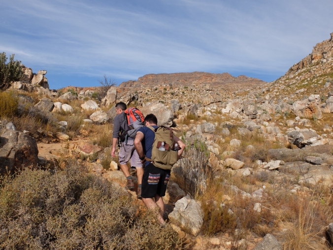
Photo by Kirsty Hawthorne
The typical Cape mountain footpath leads ruggedly up, passing low fynbos vegetation dotted with the fire surviving trees, Protea nitida (Wagon Tree Protea) & Maytenus oleoides (Mountain Maytenus). These trees have corky bark, which protects them from burning – surviving amongst fire-prone fynbos covered mountain slopes. Along with scattered boulders of sandstone, these tree specimens provide a small amount of shelter from the elements if you’re desperate.

Photo by Kirsty Hawthorne
On the day we hiked, albeit mid-winter, it was very hot and we appreciated the odd patch of shade that the Wagon trees offered. They have the most beautiful lightly coloured, wrinkled bark and distinct grey-green leaves. The tree protea flowers (creamy-white) from autumn and the odd specimen was blooming when we hiked at the start of June.

Photo by Justin Hawthorne
Gaining elevation you’ll get views back towards the vineyards and buildings at Dwarsrivier, with the burnt-orange rocky landscape ever impressive. At the corner close to Klipbokkloof, the path swings and heads towards a beautiful rock face above the shallow ravine, and the paths winds upwards to cross the non-perennial stream. Jump the gap, or proceed a little further up and cross to the left. It is easy to make the error by sticking right and heading up the rocky slope, but there are cairns pointing you left and onto a clear path.

Photo by Kirsty Hawthorne
From this vague little area, you head up to the next crest along a well-defined track again where the rock formations have your eyes struggling to know what to focus on.

Photo by Justin Hawthorne
Sneeuberg looms ahead, and just before reaching the crest of the plateau you’ll notice the tip of the Maltese Cross! Within a minute or so, you will see the impressive rock formation in all its glory, and the path heads straight towards it.

Photo by Justin Hawthorne
Approach and climb the debris scattered slopes surrounding this formation to get up close to the foot of the Cross before proceeding down the other side to appreciate the different perspective. There is a path which circumnavigates the Maltese Cross to give you all angles.

Photo by Justin Hawthorne
It will all depend on seasons, time of day that you’re at the formation along with the weather on the day to get it captured in the best conditions. We had mostly clear skies at first and felt that the north-west face had the better midday lighting, enhanced as more cloud blew over creating a dramatic feel. The ‘front’ south-eastern face definitely has more of that iconic burnt-orange colour.
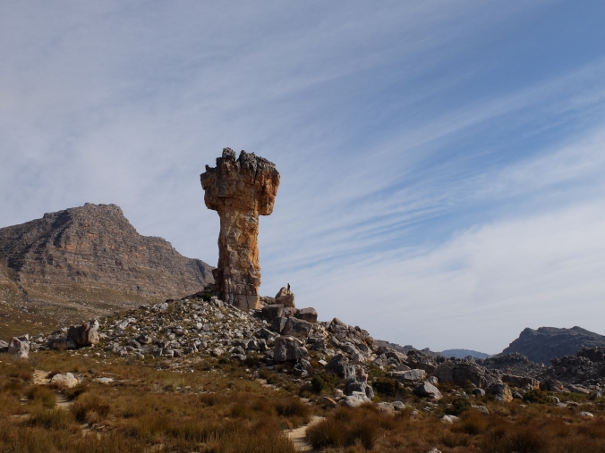
Photo by Kirsty Hawthorne
We found a good spot for a midday snack and after soaking up the beauty of the surrounding area we took the circular path back around before heading down the mountain. You look across the flats below Sneeuberg, off into the distance one can see Tafelberg and views towards The Pup & Sugarloaf also flank the region.

Photo by Kirsty Hawthorne
We descended the same way we had come, essentially doing the standard half day there-and-back hike. Doubling back on your route allows you to see things differently. One notices The Pup’s orange cliffs, the reason behind the name of Sugarloaf is understandable, the Dwarsrivier valley is more prominent, and you pick up some of the fynbos species you missed on the slog up to the Maltese Cross.

Photo by Justin Hawthorne
Once we got out of the wind, the full might of the sun took its toll and we enjoyed the brief shaded respite offered by the cliffs above Klipbokkloof and later the odd Wagon Tree Protea.

Photo by Justin Hawthorne

Photo by Justin Hawthorne
The Maltese Cross can be accessed via other routes such as from Uitkyk Pass (Duiwelsgat), Cederhoutkloof or passed when tackling Sneeuberg itself – the highest peak in the wilderness area at 2027m.

Photo by Justin Hawthorne
The Maltese Cross stands impressively alone, around 30m high, on a broad plateau at 1424m elevation. The rock type is quartzitic Table Mountain Sandstone – take some time to look closely at the rock lying about and you’ll notice the quartz pebbles embedded in the rock. It truly is a sight to behold and deserves a little time spent at the site.

Photo by Justin Hawthorne
Key information
- Start/end – Parking area at end of 6km jeep track leading from the Dwarsrivier Observatory.
- Duration – 3.5 hours (incl. 1 hr at the Maltese Cross)
- Distance – 7 km
- Altitude – approx 400m AMSL (Start 1020m AMSL)
- Grade – A
- Exposure – Low
- Water – Dwarsrivier

Photo by Justin Hawthorne
Tips
- Get the Slingsby Maps “Hike the Cederberg – Southern Section Maps 3 & 4” for the Maltese Cross.
- Get a Wild Card – you’ll save on conservation fees & permits when in the Cederberg.
- The trail is very well marked with stone cairns – look out for them if uncertain.

Photo by Justin Hawthorne
Adventure team
- Justin Hawthorne
- Darian van Eck
- Kirsty Hawthorne

Photo by Justin Hawthorne
Justin Hawthorne was given a Hyundai ix35 to use for this Cederberg Adventure by MLT Vehicle Rental. The high clearance SUV handled the entire drive very well and was especially useful in getting to the start point for the Maltese Cross hike as the jeep track is rugged in places. Driving the gravel roads between Dwarsrivier & Algeria after rain meant that things were very slippery and muddy, and the SUV was a pleasure to drive in these challenging conditions. All round, the perfect vehicle for this road trip.

Photo by Justin Hawthorne
MLT Corporation is based in Cape Town and offers a wide range of services from car hire to shuttles and tours. Their fleet of vehicles is broad, with over 300 to choose from. Contact MLT Corp at: www.mltcorp.co.za / +27 21 551 7365 / operations@mltcorp.co.za

Pingback: Travel: Weekend adventures in the Cederberg | Justin Hawthorne
Pingback: Adventures: June 2017 | Justin Hawthorne
Reblogged this on Wolf's Birding and Bonsai Blog.
LikeLike
Pingback: Hiking: 10 fantastic trails in the Western Cape | Justin Hawthorne
Pingback: Hiking: Maltese Cross in the Cederberg | Justin Hawthorne – Wolf's Birding and Bonsai Blog
Pingback: Places To Visit In South Africa’s Treasure: Cederberg | My travel blog